Tuesday, August 22, 2017

Illinois, Eclipse on Tunnel Hill Trail

Astronomers must be jealous of the meteorologists because every few months the meteorologists lead the news with the big story about a blizzard, tornado, hurricane, or heatwave.  Astronomers hope for headlines with press releases about Jupiter being aligned with Mars for the first time in 500 years.  Meh.  The night sky pretty much looks the same.  Don't care.  However there is one astrological event where the weather girls must stand aside, the total eclipse of the sun.  And the solar eclipse was coming on August 21, 2017!

I checked out the path of totality and saw its going to span the southern tip of Illinois and intersect the Tunnel Hill Trail in Shawnee National Forest.  Perfect, I'll drive 6 hours south to see the eclipse and get some riding in too.

I left a day early headed for Lone Point Campground on the shores of Lake Shelbyville (sites 62-64 are very nice).  The lake is surrounded by country roads and hiking trails so once I set up camp, I rode out to explore.

Lone Point Campground, Lake Shelbyville

Lake Shelbyville's south end
I wandered south along the west side of the lake.  Despite the fair number of dead ends, I uncovered an interesting route of hiking/biking trails and turned around at the dam.  On my return, as I climbed back to the road, my derailleur hanger snapped.  Crap!  This is a real problem as I'm at least five miles from my car on a lonely country road and the sun is setting. 


I considered my options.  Wait on the roadside to hitch a ride or figure out a way to pedal the bike without a derailleur.  A derailleur is used to not only shift gears, but keep tension on the chain so it doesn't slip off.  If I keep tension on the chain and don't switch gears, I might still be able to pedal.  I draped the chain on the gear cassette with the slack hanging below and started pedaling.  It worked!  I managed to pedal a few yards and then the chain slipped off.  Hmmm, I draped it again.  It slipped off.  Again.  I pedaled a little farther this time as I was careful not to sway the bike which, I learned, causes the chain to slip off the cassette.  Soon I discovered the optimum pitch of the bike (5 degrees to the left) that keeps the chain from sliding off.  Thankfully, it's all flat roads back to campground and I got back in time for dinner and a swim before sunset.

Converting my mountain bike to a single-speed.
In the morning, I stopped at a bicycle shop to find a replacement hanger.  It's an uncommon part and they'd need to order it.  Arg.  As I drove south to the eclipse, it occurred to me I could shorten the chain (I have a chain tool) and, much like yesterday, ride using one gear.  In Stonefort, I parked along the bike path and got out my bike tools.  After 45 minutes and two greasy hands, I had wired the useless derailleur out of the way and shortened the chain so it would stay in one gear.  I rode it around the parking lot a couple times.  Yes, it works!

My best photo of the eclipse (not)
Somewhere south of here, around 1:20 PM, the sun will be in total eclipse for 2 minutes and 41 seconds.  I packed the tools away and rode off on the Tunnel Hill Trail towards the totality.  A typical rails-to-trails route, the Tunnel Hill Trail runs southwest through agricultural fields, small towns and the Shawnee National Forest.  

At each of the small towns I rode through, the locals were gathering for the big moment.  In Carbondale, 40 miles east, much of the town gathered in the SIU football stadium to share the experience.  I heard later a small cloud blocked their view at the critical moment.  As I entered New Burnside, I checked my watch -- just a few minutes to go.  The local crowd was noisy and distracting, so I turned off the trail and rode up a quiet farm road.  The sun had been in partial eclipse for over an hour, but now there was just a sliver of sun visible.  I parked my bike next to a water tower, served lunch and waited.    

Total eclipse spooky

Same street view three minutes later
With a sliver of sun visible, the change was modest.  But when the sun was total obscured by the moon, the change was surprisingly dramatic.  The landscape darkened.  The bugs got rowdy.  I heard a cock crow.  Amazing.  But wait, doesn't the same thing happen every day a couple hours after dinner?


Note all the shadows are little crescents
The main event was over, but there was still some biking to do.  I continued south to the tunnel and the turnaround -- a very impressive bridge.

Tunnel Hill Trail's namesake

Turned around at the trestle
Biking back, I thought I was smart letting all the eclipse traffic get ahead of me.  Back at car around 4 PM, I checked Google for the fastest route home.  The route displayed wasn't what I expected.  It showed a rather roundabout route to northbound I-57.  But as my son, the Google software engineer, reminds me, "Trust the technology, Dad," so I drive as I'm instructed.  

I pulled into a rural gas station for a fill up.  The place was packed with cars and people.  The clerk seemed frazzled.  Something weird was going on.  As I drove on, I kept getting routed farther and farther from I-57.  At one small town, the police blocked main street and routed everyone back out of town. Soon Google had routed me and hundreds of other cars onto a remote country road.  So remote that the residents were out at the end of their driveways laughing, waving and taking pictures of the endless parade of cars.

I realized it was going to take a lot longer than the normal 6 hours to drive home.  I also realized Google was creating it's own traffic jams trying route drivers around the traffic bottle-necked on I-57.  I decided to find my own way home using, gasp, a paper map.  When Google routed me east, I went west and finally got away from the crowds. I pulled in the driveway after 2 a.m. 

I was one of the lucky ones.  My sister shared that one of the other teachers at College of DuPage spent 16 hours driving home from Carbondale, arriving one hour before her 8 a.m. math class on Monday.

Ratio of traffic to totality: one hour of driving for every 10 seconds of eclipse.  Next total eclipse of the sun: April 8, 2024.

State:Illinois
Date:2017-08-21
Route:Various trails/road near Lake Shelbyville
Distance:22 miles
Date:2017-08-22
Route:Stonefort to bridge past Tunnel Hill
Distance:30 miles

Saturday, July 22, 2017

Alaska, Anchorage

Anchorage, Alaska'a largest city and home to 40% of the state's population has a surprisingly wild feel.  In twenty minutes, you can get to the airport, or a trail head in the Chugash Mountains.  But what really sets Anchorage apart is the municipal bike paths.  The combination of the Tony Knowles Coastal Trail, Campbell Creek Trail and the Chester Creek Trail, creates a sweet 30 mile loop and, as it's Alaska, you are likely to meet some wildlife.


The prettiest trail in town

Only in Alaska!

A "ride-through" agreement

I tried, but my rental bike wasn't up to the challenge of these trails.


Moose in Kincaid Park
Moose near Bicentennial Park
Just south of Anchorage is the Bird to Gird Trail the runs along the Turnagain Arm.  

Bird Point

Bird to Gird Trail

Bear scat on the trail


Depot in Girdwood


Ship Creek Reservoir


State:Alaska
Date:2017-07-22 and 2017-07-23
Route:Tony Knowles, Campbell Creek, Middle Earth, Chester Creek Trail
Distance:30 miles


Date:2018-07-24
Route:Bird to Gird Trail, Brown Bear Saloon to Girdwood Depot
Distance:25 miles


Date:2022-07-30
Route:Ship Creek Trail, Downtown Anchorage to Ship Creek Reservoir
Distance:30 miles

Wednesday, July 19, 2017

Alaska, Cooper Landing

Alaska!  It started a couple years ago when I explained to my friend John I was no longer leading Sierra Club trips in the Sierra Nevada.  "Would you like to lead trips with me in Alaska?" he asked.

"Let me think about it -- Yes!" I quickly responded.  After lobbying the Alaska sub-committee with a bunch of emails and attending their Spring Meeting, I found myself driving south on Seward Highway into the heart of the Kenai Peninsula. In a few days, I would be leading a Sierra Club service trip to Denali National Park, but for now I was on my own -- to bike in Alaska!

Through my Internet research I had discovered a small fishing hamlet, Cooper Landing, boasted a number of mountain bike trails and an outfitter that would rent me a mountain bike.  I also discovered a lot of disturbing information when googling "mountain biking alaska bear attacks."

There are lot's of grizzly/brown bears in Alaska.  The best prevention for bear trouble is bear spray and traveling in a group of four or more.  The uninformed may think carrying a gun is a good idea, but studies have shown bear spray (an amped-up pepper spray) is far more likely to stop an attack than trying to draw, shoot and kill a charging grizzly bear.  Note that bear spray is not like insect repellent -- you don't spray yourself, you spray the bear.  Misguided greenhorns have been to known to treat their tents with bear spray which probably results in a flavorful peppery aroma.

The benefit of traveling in a group is not only a bear is less likely to challenge a pack of humans, but larger groups make more noise and are less likely to surprise a bear.  And that's really the issue, as grizzly bears are not vicious man-eaters but more like cattle peacefully grazing the bounty of the wild Alaskan landscape.  When their breakfast is rudely interrupted, grizzlies are apt to provide a polite mauling for violating bear etiquette.

After staying at the Sunrise Inn (not bad, small showers), I drove to the location of the bike rental, but all I found was an parking lot and a billboard, "Adventure Guru Bike Rental, call ..."  WTH?  I called the number.  Yes, this is the bike rental.  Yes, my bike is ready.  Yes, here's directions to his house a couple miles away.  Turns out the Adventure Guru renting bikes out of his garage is like most Alaskan fishermen working multiple gigs to make a living.  Except sometimes the tourists are the salmon, to be harvested every way possible while we are in season.

I decided to start with a less risky route on Snug Harbor Road which follows the shore of Kenia Lake and then ascends to Cooper Lake.

Warning sign on Snug Harbor Road


A bear on Snug Harbor Road
Paved for the first few miles and paralleled by a new paved bike path, Snug Harbor Road quickly turns to gravel and what the little traffic there was disappeared.

Cooper Lake, Alaska
The climb to Cooper Lake is short but steep and I was rewarded with a view of a pristine Alaskan lake.  This same road leads to the start of the Russian Lakes Trail, so I explored the single track a couple of miles too.  As it's late summer for Alaska, the undergrowth is thick and tall.  One plant dominates the landscape.  It features huge leaves the size on my head and large flowers that resemble Queen Anne's Lace.  It's so thick, it strikes my arms, legs and helmet as I ride.
Russian Lakes Trail

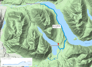
Snug Harbor to Cooper Lake and Russian Lakes Trail


Sign you'll find only in Alaska


Start of Crescent Creek Trail
The second day in Cooper Landing I was ready to tackle some Alaskan single track.  The Crescent Creek trail head was just down the road the Sunrise Inn, so I biked directly from the hotel.  I rode past the Quartz Creek campground of the shores of Kenai Lake (highly recommended) on the gravel road to the trail head.  From there to Crescent Lake, it's 5.5 miles of sweet single track.  


Lower trail is a wide well-packed


The upper trail narrows and the landscape opens into a beautiful valley


The upper trail also features bear scat!


I decided I needed more noise, so I rigged this piece of Gatorade bottle to click my spokes.


Sunrise Inn to Crescent Lake


On my return to Cooper Landing in 2018, I biked the Skilak Wildlife Refuge.  The main road through the refuge is a gravel road with some spur roads to various lakes and campgrounds.  I rode the entire length.  The route from the eastern entrance to Engineer Lake is rolling and pretty.  The western section is forgettable.

Western section is not very scenic


"Due to recent bear incident all tent camping closed until further notice"

For lunch, I stopped at Lower Ohmer Lake.  While I was there a ranger pulled up and asked if I had seen any bears.  I had seen the brief news item and had noticed the signs noting the refuge campgrounds had been closed to tent camping, but no bears.  "Hey, so what happened?"

The ranger gave me the details.  Four days earlier, a woman on a solo multi-day bike trip camped here -- at my lunch spot.  As she was in a tent, she wisely stored her food in another camper's pickup.  Despite the precaution, later that night a black bear tore open her tent and bit her on the foot.  She wasn't severely injured because, apparently, she wore shoes while she slept.  After the the brief attack, the bear left the area.  The women cancelled the rest of her bike trip.  I don't blame her.


The perfect spot for lunch (unless the bear comes back)


Route through Skilak WRA


Russian Falls Trail
Driving in mist shrouded moose country ...


... near the Exit Glacier ...


... cool!


Salmon jumping at Russian Falls

Kenai River Canyon

Russian Falls route
Days later as the Sierra Club group drove to Denali, I used my opportunity in the front seat to learn what I could from the bus driver.  A common theme in Alaska, he had an interesting back story of jobs and adventures.

"So why did you give up leading backpacking trips?" I asked.

"I got tired of rolling up wet tents."  Alaskan wisdom in a nutshell.


Cow Parsnip, has a nasty photosensitive irritant

When I discussed my riding adventures with the driver he interrupted me.  "How many days ago were you biking?" he asked.

"Ah, five days ago." I answered.

"Yea, you should be OK then."  Turns out the giant Queen Anne's Lace is called Cow Parsnip, a relative of Devil's Club, and grows everywhere in the rainy Kenai Peninsula.  The leaves produce a nasty photosensitive sap that generates huge itchy blisters on skin and can even cause blindness.  Much worse than Poison Ivy.  On the days of my exposure, it had luckily been overcast so I avoided the repercussions of my ignorance.

State:Alaska
Date:2017-07-19
Route:Snug Harbor Road to Cooper Lake and Russian Lake Trail
Distance:29 miles


Date:2017-07-20
Route:Sunrise Inn to Crescent Creek Trail
Distance:16 miles

Date:2018-07-25
Route:Skilak National Wildlife Refuge and Russian Falls Trail
Distance:43 miles

Tuesday, June 20, 2017

Oregon, Fat Tires in Bandon, How I met your mother

Fresh out of college and on my first day of work, I was led to an empty desk at Time Magazine's offices in Chicago.  "Mona's on vacation in Australia and New Zealand for four weeks, so you can sit here until we find you a permanent spot."

As I filled out the HR forms and performed other new-employee busy work, I couldn't help but snoop through the cubicle.  After finishing her roll of Life Savers, I noticed an exercise log on the wall calendar.  Each day had a careful notations, "Ran 10, Biked 40, Swam 1, Ran 12."  "What are these units?" I thought to myself.  "They can't be miles!"  

I finally met Mona when we were assigned to work together to investigate why Dallas subscribers missed their magazines last week.  Working together, I learned that Mona was quite the runner, training for her next marathon, and the units were indeed miles.  I also learned she thought I was cocky and annoying.  I thought she was cute.

Eventually when I was scrambling for a date to a friend's wedding, I asked Mona out.  She said yes and, despite the minus 60-degree windchill, we had a nice time.  We refer to this period as "Round One."  "Round One" consisted of me chasing Mona while she barely tolerated me.  Our dates eventually devolved to the point that when I asked her out, she replied "I'm too depressed to go out with you."  Ouch. OK, I can take a hint.  Thirty years later she still won't completely explain this statement, but I think there was another suitor in the picture.

When the holidays rolled around again, I asked another co-worker, Hilde, to the company Christmas Party.  I don't know why I asked Hilde as I wasn't attracted to her.  At the party, Hilde and I were dancing when I noticed Mona looking lonely against the wall.  So I ditched Hilde in the bar and asked Mona to dance.  The unintentional jealousy gambit apparently worked because she enthusiastically agreed.  We danced the rest of the night together and that began "Round Two."  Round Two ended on June 13, 1987 we when were married.

Luckiest day of my life!
Skip forward three decades and we are celebrating our 30th wedding anniversary with a drive down the West Coast.  By this time our kids have both relocated to the West Coast, Matt to the Silicon Valley and Lauren to Seattle.  Our itinerary starts with a visit to Orcas Island with Lauren and ends in Redwood City with a visit with Matt.  Stops in between include: Olympic National Park, Hurricane Ridge, Hoh River, Quinault, Columbia River Gorge, Portland, Roads End State Park, Depoe Bay, Otters Rock, Bandon, Crescent City, Smith River, Humboldt Redwoods State Park, Benbow, and Santa Rosa.


Still crazy after all these years
The Pacific Coast is a epic road trip featuring stunning views, abundant wildlife and the world's best collection of trees.  Our most noteworthy wildlife encounter occurred when we came upon a black bear sow and her cubs on the return leg of a Hoh River Trail day hike.  "Don't run," I cautioned my wife before I pointed out the bears on the trail ahead.  Following the typical wildness recommendations, we stood close together, tried to look big, and made a lot of noise.  This caused the cubs to immediately climb the nearest tree.  Hmmm, not so good.  The treed cubs are right next to the path essentially blocking our exit.

Momma bear and cubs!
We retreated a few hundred yards to our lunch spot along the river and conferred with a fellow hiker.  She had no ideas either.  After waiting apprehensively for a few minutes we backtracked further and discovered a faint social trail branching off the main trail.  With nothing to lose, we followed the secondary trail into the dense woods where it luckily rejoined the main trail beyond the treed cubs.  On the way out, we did enjoy the expressions of the other hikers when we warned them of the bear family ahead.  In retrospect, we should have just moved off the path and left the bear family pass by.

Abundant wildlife
The coastal highway's scenic panoramas are as regular Old Style signs on Irving Park Road.  Every few miles is something amazing.  Need a break, just pull over at the next sign labelled "Scenic Outlook."


Need a break?
A view


Another view

View for napping


World's largest Sitka Spruce
Quinault Valley rain forest is home is several of the world's largest trees!
The mighty larch (I mean redwood)

If you dress too casually, someone may ask you for extra towels.

Mona after a few beers in Portland looking to score


"All the little chicks with the crimson lips go..."
The trip's bicycling highlight is the beaches of Bandon, Oregon.  We rented fat tires bikes from South Coast Bicycles (recommended) and explored the beaches both south and north of town. 


Sea stacks of Bandon, OR


The fat tire bikes make beach riding a blast.  Staying off the powdery sand above high tide and out of the deeper water, the fatties allow us to cruise around and through the incredible rock protuberances with ease.


Yea Baby!

After we explored the southern beach, we headed north of town.  The Pacific Coast Highway caters to bicyclists and much of it has wide shoulders or designated bike lanes.  Some bridges were built in less enlightened times and don't provide room for bikes.  The work around is warning lights activated by a roadside button.  Theoretically, the truck driver will notice the flashing lights and slow down before pushing us off into the Coquille River.


On the shoulder before the narrow bridge
The northern beaches are quite nice too, but lack the dramatic sea stacks.

Bandon bike route
After 13 days, we arrive in Redwood City.  Matt and his then girlfriend, now wife, Jordan hosted us for delicious dinner and a hike in the East Bay.  Matt was working at Google at the time and my biking objective was a ride on those crazy multi-colored Google bikes. 

Sculptures representing the various version of the Android operating system -- Gingerbread and Honeycomb.
Always the polite host, Matt led us on a Google campus tour and a G-bike ride!

If you look closely, you'll notice Matt's sunglasses match the bike

Hiking the East Bay with Matt and Jordan (our future daughter-in-law) 
On our last day we took Zoey to a dog park.  After watching the behavior of dogs, we imagined what if humans at a bar behaved like dogs at a dog park.  Every time a new human entered the bar, the entire crowd would run up to greet them at the door with some intimate sniffing.  Next the group would chase each other around the room until tiring.  Which would be followed by the lapping of beer from large communal bowls. 

State:Oregon
Date:2017-06-20
Route:Bandon's beaches, south and north
Distance:20 miles